
Thank you for supporting this site ❤️
Make a donation
Make a donation
Norderstedt topographic map
Click on the map to display elevation.
Thank you for supporting this site ❤️
Make a donation
Make a donation
About this map
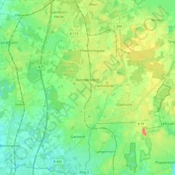
Name: Norderstedt topographic map, elevation, terrain.
Location: Norderstedt, Kreis Segeberg, Schleswig-Holstein, Germany (53.64812 9.93476 53.75947 10.07294)
Average elevation: 29 m
Minimum elevation: 8 m
Maximum elevation: 71 m
Thank you for supporting this site ❤️
Make a donation
Make a donation
Other topographic maps
Click on a map to view its topography, its elevation and its terrain.
Strand Seekamp
Germany > Schleswig-Holstein > Kreis Segeberg > Berlin > Seekamp
Average elevation: 38 m