
Guildford topographic map
Interactive map
Click on the map to display elevation.
About this map
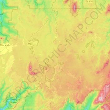
Name: Guildford topographic map, elevation, terrain.
Location: Guildford, Waratah-Wynyard, 塔斯马尼亚州, 澳大利亚 (-41.59991 145.50515 -41.33644 145.85325)
Average elevation: 628 m
Minimum elevation: 232 m
Maximum elevation: 1,129 m
Other topographic maps
Click on a map to view its topography, its elevation and its terrain.
Arm River Regional Reserve
Arm River Regional Reserve, Mersey Forest Road, Meander Valley, 塔斯马尼亚州, 澳大利亚
Average elevation: 573 m
Upper Natone
澳大利亚 > 塔斯马尼亚州 > Upper Natone
Upper Natone, City of Burnie, 塔斯马尼亚州, 澳大利亚
Average elevation: 364 m
National Park
澳大利亚 > 塔斯马尼亚州 > National Park
National Park, Derwent Valley, 塔斯马尼亚州, 澳大利亚
Average elevation: 497 m
Meadowbank Lake
Meadowbank Lake, Hamilton, Central Highlands, 塔斯马尼亚州, 澳大利亚
Average elevation: 176 m