
Thank you for supporting this site ❤️
Make a donation
Make a donation
Bagnaia topographic map
Click on the map to display elevation.
Thank you for supporting this site ❤️
Make a donation
Make a donation
About this map
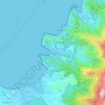
Name: Bagnaia topographic map, elevation, terrain.
Location: Bagnaia, Rio, Livorno, Toscana, 57039, Italia (42.79048 10.34438 42.83048 10.38438)
Average elevation: 67 m
Minimum elevation: -2 m
Maximum elevation: 500 m
Thank you for supporting this site ❤️
Make a donation
Make a donation
Other topographic maps
Click on a map to view its topography, its elevation and its terrain.