
Thank you for supporting this site ❤️
Make a donation
Make a donation
Havens Corners topographic map
Click on the map to display elevation.
Thank you for supporting this site ❤️
Make a donation
Make a donation
About this map
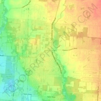
Name: Havens Corners topographic map, elevation, terrain.
Average elevation: 296 m
Minimum elevation: 266 m
Maximum elevation: 318 m
Thank you for supporting this site ❤️
Make a donation
Make a donation
Other topographic maps
Click on a map to view its topography, its elevation and its terrain.
Thank you for supporting this site ❤️
Make a donation
Make a donation
Thank you for supporting this site ❤️
Make a donation
Make a donation
Thank you for supporting this site ❤️
Make a donation
Make a donation
Jefferson Township
United States > Ohio > Franklin County
Blacklick Creek and its associated tributaries of its watershed such as Swisher Creek flow through Jefferson Township. Big Walnut Creek is also to the west of the township while some of its tributaries such as Rocky Fork Creek travel through the western part of Jefferson Township. This has caused the…
Average elevation: 293 m
Thank you for supporting this site ❤️
Make a donation
Make a donation
Pickerington Ponds Metro Park
United States > Ohio > Franklin County > Columbus
Average elevation: 241 m
Thank you for supporting this site ❤️
Make a donation
Make a donation
Edward S. Thomas Nature Preserve
United States > Ohio > Franklin County > Columbus
Average elevation: 275 m
Thank you for supporting this site ❤️
Make a donation
Make a donation