
Cape Breton County topographic map
Interactive map
Click on the map to display elevation.
About this map
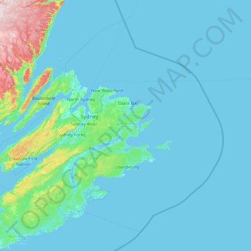
Name: Cape Breton County topographic map, elevation, terrain.
Average elevation: 44 m
Minimum elevation: -3 m
Maximum elevation: 490 m
Other topographic maps
Click on a map to view its topography, its elevation and its terrain.
Framboise
Canada > Nova Scotia > Municipality of the County of Richmond
Framboise, Municipality of the County of Richmond, Richmond County, Nova Scotia, Canada
Average elevation: 23 m
Kirkhill
Canada > Nova Scotia > Kirkhill
Kirkhill, Municipality of the County of Cumberland, Cumberland County, Nova Scotia, B0M 1S0, Canada
Average elevation: 142 m
Albert Bridge
Canada > Nova Scotia > Albert Bridge
Albert Bridge, Cape Breton Regional Municipality, Cape Breton County, Nova Scotia, Canada
Average elevation: 46 m
Bras d'Or Lake
Canada > Nova Scotia > Potlotek First Nation
Bras d'Or Lake, Chapel Island 7 Trail, Chapel Island 5, Potlotek First Nation, Richmond County, Nova Scotia, B0E 3B0, Canada
Average elevation: 0 m
Cape Breton Island
Canada > Nova Scotia > Margaree Valley
Cape Breton Island, Margaree Valley, Municipality of the County of Inverness, Inverness County, Nova Scotia, Canada
Average elevation: 66 m
Clarence
Canada > Nova Scotia > Clarence
Clarence, Municipality of the County of Annapolis, Annapolis County, Nova Scotia, B0S 1M0, Canada
Average elevation: 74 m
Long Point
Canada > Nova Scotia > Long Point
Long Point, Municipality of the County of Inverness, Inverness County, Nova Scotia, Canada
Average elevation: 85 m
Upper Branch
Canada > Nova Scotia > Upper Branch
Upper Branch, Municipality of the District of Lunenburg, Lunenburg County, Nova Scotia, B4V 4X8, Canada
Average elevation: 95 m
Economy
Canada > Nova Scotia > Economy
Economy, Municipality of Colchester, Colchester County, Nova Scotia, B0M 1J0, Canada
Average elevation: 93 m