
Thank you for supporting this site ❤️
Make a donation
Make a donation
Shoham topographic map
Click on the map to display elevation.
Thank you for supporting this site ❤️
Make a donation
Make a donation
About this map
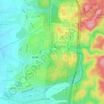
Name: Shoham topographic map, elevation, terrain.
Location: Shoham, Ramla Subdistrict, Center District, Israel (31.98258 34.93170 32.02248 34.96798)
Average elevation: 101 m
Minimum elevation: 49 m
Maximum elevation: 196 m
Thank you for supporting this site ❤️
Make a donation
Make a donation
Other topographic maps
Click on a map to view its topography, its elevation and its terrain.
Thank you for supporting this site ❤️
Make a donation
Make a donation
Modiin-Maccabim-Reut
Israel > Center District > Ramla Subdistrict > Modiin-Maccabim-Reut
Average elevation: 240 m
Thank you for supporting this site ❤️
Make a donation
Make a donation