
Thank you for supporting this site ❤️
Make a donation
Make a donation
Bersham topographic map
Click on the map to display elevation.
Thank you for supporting this site ❤️
Make a donation
Make a donation
About this map
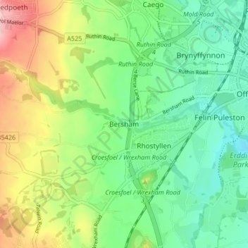
Name: Bersham topographic map, elevation, terrain.
Location: Bersham, Wrexham, Wales, LL14 4LP, United Kingdom (53.01510 -3.05324 53.05510 -3.01324)
Average elevation: 122 m
Minimum elevation: 63 m
Maximum elevation: 231 m
Thank you for supporting this site ❤️
Make a donation
Make a donation
Other topographic maps
Click on a map to view its topography, its elevation and its terrain.