
Thank you for supporting this site ❤️
Make a donation
Make a donation
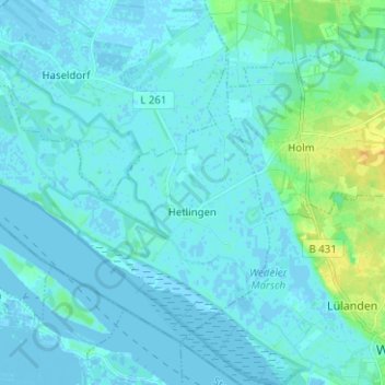
Hetlingen topographic map
Click on the map to display elevation.
Thank you for supporting this site ❤️
Make a donation
Make a donation
Hetlingen
Am 3. Januar 1976 wurde aufgrund eines Deichbruchs bei Hetlingen die gesamte Haseldorfer Marsch bei einer schweren Sturmflut überflutet. Es entstand ein Sachschaden in dreistelliger Millionenhöhe. Wie durch ein Wunder kam kein Mensch zu Tode.
Thank you for supporting this site ❤️
Make a donation
Make a donation
About this map
Name: Hetlingen topographic map, elevation, terrain.
Average elevation: 3 m
Minimum elevation: -4 m
Maximum elevation: 22 m
Thank you for supporting this site ❤️
Make a donation
Make a donation
Other topographic maps
Click on a map to view its topography, its elevation and its terrain.
Tävsmoor/Haselauer Moor
Deutschland > Schleswig-Holstein > Kreis Pinneberg > Appen
Average elevation: 9 m
Thank you for supporting this site ❤️
Make a donation
Make a donation
Liether Kalkgrube
Deutschland > Schleswig-Holstein > Kreis Pinneberg > Klein Nordende
Average elevation: 14 m