
Make a donation
Franklin topographic map
Click on the map to display elevation.
Make a donation
About this map
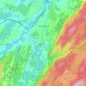
Name: Franklin topographic map, elevation, terrain.
Average elevation: 230 m
Minimum elevation: 139 m
Maximum elevation: 395 m
Make a donation
Other topographic maps
Click on a map to view its topography, its elevation and its terrain.
Make a donation
Montague Township
United States > New Jersey > Sussex County > Montague Township
Montague Township is a township in Sussex County, in the U.S. state of New Jersey, in the New York City Metropolitan Area. As of the 2020 United States census, the township's population was 3,792, a decrease of 55 (−1.4%) from the 2010 census count of 3,847, which in turn reflected an increase of 435…
Average elevation: 178 m
Make a donation
Make a donation
Make a donation
Lake Neepaulin
United States > New Jersey > Sussex County > Wantage
Lake Neepaulin is a man-made lake created from the damming of Neepaulakating Creek, a small mountain stream that was not named until 2002. The creek's headwaters are located approximately 0.4 miles (0.64 km) northwest of the north end of Lake Neepaulin. These headwaters are located a short distance south of…
Average elevation: 172 m
Make a donation
Lafayette
United States > New Jersey > Sussex County > Lafayette Township > Lafayette
Average elevation: 181 m
Sunrise Moutain Overlook
United States > New Jersey > Sussex County > Frankford Township
Average elevation: 344 m
Swartswood
United States > New Jersey > Sussex County > Stillwater Township > Swartswood
Average elevation: 196 m
Make a donation