
Thank you for supporting this site ❤️
Make a donation
Make a donation
Gorsem topographic map
Click on the map to display elevation.
Thank you for supporting this site ❤️
Make a donation
Make a donation
Gorsem
Gorsem ligt in Vochtig-Haspengouw, onmiddellijk ten noordwesten van de kom van Sint-Truiden. Het dorp sluit aan bij het bosrijke Kasteeldomein van Duras in het westen. Gorsem ligt in de vallei van de Molenbeek. De hoogte bedraagt 40 à 45 meter.
Thank you for supporting this site ❤️
Make a donation
Make a donation
About this map
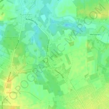
Name: Gorsem topographic map, elevation, terrain.
Location: Gorsem, Sint-Truiden, Hasselt, Limburg, Vlaanderen, België (50.82726 5.15493 50.84843 5.17649)
Average elevation: 38 m
Minimum elevation: 26 m
Maximum elevation: 51 m
Thank you for supporting this site ❤️
Make a donation
Make a donation
Other topographic maps
Click on a map to view its topography, its elevation and its terrain.
Thank you for supporting this site ❤️
Make a donation
Make a donation
Thank you for supporting this site ❤️
Make a donation
Make a donation