
Laramie topographic map
Interactive map
Click on the map to display elevation.
About this map
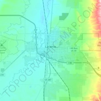
Name: Laramie topographic map, elevation, terrain.
Location: Laramie, Albany County, Wyoming, United States (41.27742 -105.69729 41.33581 -105.52819)
Average elevation: 2,219 m
Minimum elevation: 2,166 m
Maximum elevation: 2,462 m
Laramie (/ˈlærəmi/) is a city in and the county seat of Albany County, Wyoming, United States known for its high elevation at 7,200 feet, railroad history, and as the higher-education center for the state of Wyoming. The population was estimated 31,407 in 2020, making it the 4th most populous city in Wyoming. Located on the Laramie River in southeastern Wyoming, the city is west of Cheyenne and 25 miles north of the Colorado state line, at the junction of Interstate 80 and U.S. Route 287.
Other topographic maps
Click on a map to view its topography, its elevation and its terrain.
Jelm Mountain
United States > Wyoming > Albany County
Jelm Mountain, Albany County, Wyoming, 82063, United States
Average elevation: 2,660 m
Laramie
United States > Wyoming > Albany County
Laramie, Albany County, Wyoming, United States
Average elevation: 2,219 m
Centennial
United States > Wyoming > Albany County
Centennial, Albany County, Wyoming, 82055, United States
Average elevation: 2,577 m
Jelm
United States > Wyoming > Albany County
Jelm, Albany County, Wyoming, United States
Average elevation: 2,422 m
PhinDeli Town Buford
United States > Wyoming > Albany County
PhinDeli Town Buford, Albany County, Wyoming, United States
Average elevation: 2,386 m
North Twin Lakes
United States > Wyoming > Albany County
North Twin Lakes, Albany County, Wyoming, United States
Average elevation: 3,258 m
Black Mountain
United States > Wyoming > Albany County
Black Mountain, Albany County, Wyoming, United States
Average elevation: 2,172 m
Laramie
United States > Wyoming > Albany County > Laramie
Laramie, Albany County, Wyoming, 82070, United States
Average elevation: 2,299 m
Medicine Bow Peak
United States > Wyoming > Albany County
Medicine Bow Peak, Albany County, Wyoming, United States
Average elevation: 3,396 m