
Thank you for supporting this site ❤️
Make a donation
Make a donation
Golães topographic map
Click on the map to display elevation.
Thank you for supporting this site ❤️
Make a donation
Make a donation
About this map
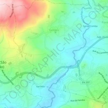
Name: Golães topographic map, elevation, terrain.
Location: Golães, Fafe, Braga, Portugal (41.44397 -8.21197 41.47404 -8.18281)
Average elevation: 327 m
Minimum elevation: 237 m
Maximum elevation: 547 m
Thank you for supporting this site ❤️
Make a donation
Make a donation
Other topographic maps
Click on a map to view its topography, its elevation and its terrain.
Thank you for supporting this site ❤️
Make a donation
Make a donation