
Djelida topographic map
Interactive map
Click on the map to display elevation.
About this map
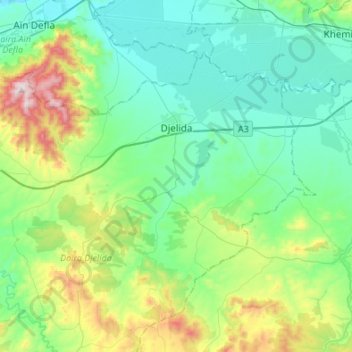
Name: Djelida topographic map, elevation, terrain.
Location: Djelida, Daïra Djelida, Aïn Defla, 44100, Algérie (36.09428 1.91651 36.24964 2.18681)
Average elevation: 411 m
Minimum elevation: 224 m
Maximum elevation: 1,019 m
Other topographic maps
Click on a map to view its topography, its elevation and its terrain.
Koudiet Zeboudj
Algérie > Aïn Defla > Daïra Djelida > Bourached
Koudiet Zeboudj, Bourached, Daïra Djelida, Aïn Defla, Algérie
Average elevation: 302 m