
Thank you for supporting this site ❤️
Make a donation
Make a donation
Passail topographic map
Click on the map to display elevation.
Thank you for supporting this site ❤️
Make a donation
Make a donation
About this map
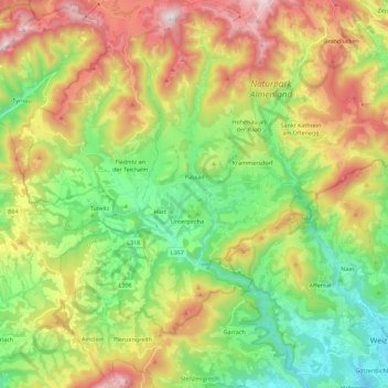
Name: Passail topographic map, elevation, terrain.
Location: Passail, Bezirk Weiz, Styria, 8162, Austria (47.19847 15.43653 47.35148 15.58373)
Average elevation: 875 m
Minimum elevation: 452 m
Maximum elevation: 1,524 m
Thank you for supporting this site ❤️
Make a donation
Make a donation
Other topographic maps
Click on a map to view its topography, its elevation and its terrain.