Geolocate

Kos topographic map

Interactive map

Click on the map to display elevation.

About this map

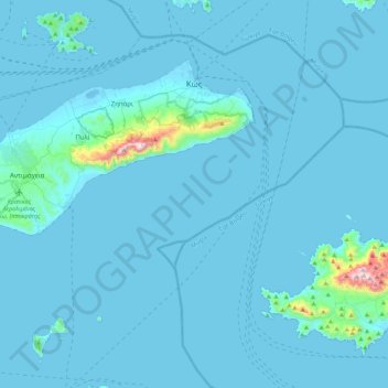
Name: Kos topographic map, elevation, terrain.

Location: Kos, Kos Regional Unit, South Aegean Region, Aegean, Greece (36.67169 26.91719 36.91616 27.35599)

Average elevation: 25 m

Minimum elevation: -5 m

Maximum elevation: 827 m

Other topographic maps

Click on a map to view its topography, its elevation and its terrain.

Mykonos

Greece > Aegean > Mykonos Regional Unit > Plintri

Mykonos (/ˈmɪkənɒs, -noʊs/, UK also /ˈmiːk-/; Greek: Μύκονος [ˈmikonos]) is a Greek island, part of the Cyclades, lying between Tinos, Syros, Paros and Naxos. The island has an area of 85.5 square kilometres (33.0 sq mi) and rises to an elevation of 341 metres (1,119 feet) at its highest point.…

Average elevation: 38 m

Icaria

Greece > Aegean > Ikaria Regional Unit

Icaria is one of the middle islands of the northern Aegean, 255.303 square kilometres (98.573 sq mi) in area with 102 miles (164 kilometres) of coastline and a population of 8,312 inhabitants. The topography is a contrast between verdant slopes and barren steep rocks. The island is mountainous for the most…

Average elevation: 87 m

Kalymnos

Greece > Aegean > Kalmynos Regional Unit

Kalymnos is mostly mountainous with complicated topography. There are three main chains going from W-NW to E-SE, and a fourth which extends NW the length of the peninsula. The coastline is very irregular, with many sheltered coves. There are some springs, one among them being thermal. The soil is mainly…

Average elevation: 75 m

Naxos

Greece > Aegean > Naxos Regional Unit

Naxos experiences both a Mediterranean climate (Csa) and a hot semi-arid climate (Köppen climate classification: BSh) depending on the location. According to the stations of the National Observatory of Athens, various locations in Naxos have a hot semi-arid climate. Inland areas of the island are much wetter…

Average elevation: 112 m

Plintri

Greece > Aegean > Mykonos Regional Unit

Average elevation: 59 m

Rhodes

Greece > Aegean

Rhodes is situated 363 km (226 mi) east-southeast from the Greek mainland, and 18 km (11 mi) from the southern shore of Turkey. Mount Attavyros, at 1,216 m (3,990 ft), is the island's highest point of elevation.

Average elevation: 67 m

Ios

Greece > Aegean

The highest elevation (723 m, 2372 ft) is the Kastro (Greek: Κάστρο) peak also called Pyrgos (Greek: Πύργος), located in the center of the island, while around the Kastro are the next three Highest peaks: Xylodema (Greek: Ξυλόδεμα) (660 m, 2165 ft), Kostiza (Greek: Κοστίζα) (586 m,…

Average elevation: 73 m

Stegna

Greece > Aegean > Stegna

Average elevation: 81 m

Andros

Greece > Aegean

Average elevation: 83 m

Chios

Greece > Aegean > Chios Regional Unit

Average elevation: 99 m