
Marysville topographic map
Interactive map
Click on the map to display elevation.
About this map
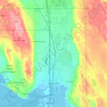
Name: Marysville topographic map, elevation, terrain.
Location: Marysville, Snohomish County, Washington, United States (48.01984 -122.28651 48.16329 -122.10961)
Average elevation: 72 m
Minimum elevation: -3 m
Maximum elevation: 201 m
The city's topography varies from the low-lying downtown, located along the banks of Ebey Slough 5 feet (1.5 m) above sea level, rising to 160 feet (49 m) near Smokey Point and over 465 feet (142 m) in the eastern highlands. Marysville sits in the watershed of two major creeks, Quilceda Creek and Allen Creek, and approximately 70 minor streams that flow into Ebey Slough and Snohomish River. During the early 20th century, repeated controlled flooding and other engineering works in the Snohomish River delta contributed to the replenishment of the area's fertile silty soil for use in farming.
Other topographic maps
Click on a map to view its topography, its elevation and its terrain.
Edmonds
United States > Washington > Snohomish County
Edmonds, Snohomish County, Washington, United States
Average elevation: 44 m
Arlington
United States > Washington > Snohomish County
Arlington, Snohomish County, Washington, United States
Average elevation: 60 m
Monroe
United States > Washington > Snohomish County
Monroe, Snohomish County, Washington, 98272, United States
Average elevation: 49 m
Snohomish
United States > Washington > Snohomish County
Snohomish, Snohomish County, Washington, 98291, United States
Average elevation: 39 m
Mukilteo
United States > Washington > Snohomish County
Mukilteo, Snohomish County, Washington, United States
Average elevation: 89 m
Lake Stickney
United States > Washington > Snohomish County
Lake Stickney, Snohomish County, Washington, United States
Average elevation: 1,105 m
Martha Lake
United States > Washington > Snohomish County
Martha Lake, Snohomish County, Washington, United States
Average elevation: 132 m
Picnic Point-North Lynnwood
United States > Washington > Snohomish County
Picnic Point-North Lynnwood, Snohomish County, Washington, 98087, United States
Average elevation: 127 m
Sisco Heights
United States > Washington > Snohomish County
Sisco Heights, Snohomish County, Washington, United States
Average elevation: 132 m
Everett
United States > Washington > Snohomish County
Everett, Snohomish County, Washington, United States
Average elevation: 69 m
Woods Creek
United States > Washington > Snohomish County
Woods Creek, Snohomish County, Washington, United States
Average elevation: 104 m
Index
United States > Washington > Snohomish County
Index, Snohomish County, Washington, United States
Average elevation: 366 m
Clearview
United States > Washington > Snohomish County
Clearview, Snohomish County, Washington, 98296, United States
Average elevation: 148 m
Lynnwood
United States > Washington > Snohomish County
Lynnwood, Snohomish County, Washington, 98037, United States
Average elevation: 121 m
Jamison Corner
United States > Washington > Snohomish County > Three Lakes
Jamison Corner, Three Lakes, Snohomish County, Washington, United States
Average elevation: 142 m
Lochsloy
United States > Washington > Snohomish County
Lochsloy, Snohomish County, Washington, United States
Average elevation: 112 m
Tulalip Bay
United States > Washington > Snohomish County
Tulalip Bay, Snohomish County, Washington, 98207, United States
Average elevation: 28 m
Esperance
United States > Washington > Snohomish County > Esperance
Esperance, Snohomish County, Washington, United States
Average elevation: 118 m
Oso
United States > Washington > Snohomish County
Oso, Snohomish County, Washington, United States
Average elevation: 118 m
Bryant
United States > Washington > Snohomish County
Bryant, Snohomish County, Washington, United States
Average elevation: 63 m
Pilchuck
United States > Washington > Snohomish County
Pilchuck, Snohomish County, Washington, 98209, United States
Average elevation: 199 m
Cathcart
United States > Washington > Snohomish County > Cathcart
Cathcart, Snohomish County, Washington, United States
Average elevation: 88 m
Northwest Snohomish
United States > Washington > Snohomish County > Snohomish
Northwest Snohomish, Snohomish, Snohomish County, Washington, 98291, United States
Average elevation: 53 m
Big Four Ice Caves
United States > Washington > Snohomish County
Big Four Ice Caves, Big Four Ice Caves Trail, Snohomish County, Washington, United States
Average elevation: 911 m
Granite Falls
United States > Washington > Snohomish County
Granite Falls, Snohomish County, Washington, United States
Average elevation: 120 m
Bowser Lake
United States > Washington > Snohomish County
Bowser Lake, Snohomish County, Washington, United States
Average elevation: 1,393 m
Lake Stevens
United States > Washington > Snohomish County
Lake Stevens, Snohomish County, Washington, 98258, United States
Average elevation: 82 m
Edmonds
United States > Washington > Snohomish County > Edmonds > Edmonds
Edmonds, Snohomish County, Washington, 98020-4180, United States
Average elevation: 50 m
Robe
United States > Washington > Snohomish County
Robe, Snohomish County, Washington, United States
Average elevation: 407 m
Arlington Heights
United States > Washington > Snohomish County
Arlington Heights, Snohomish County, Washington, United States
Average elevation: 136 m
Lakewood
United States > Washington > Snohomish County > Marysville
Lakewood, Marysville, Snohomish County, Washington, 09223, United States
Average elevation: 44 m
Maltby
United States > Washington > Snohomish County
Maltby, Snohomish County, Washington, 98296, United States
Average elevation: 117 m
Bald Mountain East Peak
United States > Washington > Snohomish County
Bald Mountain East Peak, Snohomish County, Washington, United States
Average elevation: 1,052 m
Dagger Lake
United States > Washington > Snohomish County
Dagger Lake, Snohomish County, Washington, United States
Average elevation: 294 m
Sultan
United States > Washington > Snohomish County
Sultan, Snohomish County, Washington, 98294, United States
Average elevation: 78 m
Seattle Hill-Silver Firs
United States > Washington > Snohomish County > Seattle Hill-Silver Firs
Seattle Hill-Silver Firs, Snohomish County, Washington, 98208, United States
Average elevation: 93 m
Everett
United States > Washington > Snohomish County > Everett
Everett, Snohomish County, Washington, 98120, United States
Average elevation: 67 m
Brier
United States > Washington > Snohomish County
Brier, Snohomish County, Washington, United States
Average elevation: 105 m
Snohomish
United States > Washington > Snohomish County > Snohomish > Snohomish
Snohomish, Snohomish County, Washington, 98291, United States
Average elevation: 36 m
Totem Park
United States > Washington > Snohomish County > Arlington > Totem Park
Totem Park, Arlington, Snohomish County, Washington, 09223, United States
Average elevation: 34 m
Mill Creek
United States > Washington > Snohomish County > Mill Creek > Mill Creek
Mill Creek, Snohomish County, Washington, 98012, United States
Average elevation: 129 m
Lynnwood
United States > Washington > Snohomish County > Lynnwood > Lynnwood
Lynnwood, Snohomish County, Washington, 98036, United States
Average elevation: 112 m
Granite Falls
United States > Washington > Snohomish County > Granite Falls > Granite Falls
Granite Falls, Snohomish County, Washington, 98252, United States
Average elevation: 143 m
Stanwood
United States > Washington > Snohomish County > Stanwood
Stanwood, Snohomish County, Washington, United States
Average elevation: 20 m
Monte Cristo
United States > Washington > Snohomish County
Monte Cristo, Snohomish County, Washington, United States
Average elevation: 1,179 m
Verlot
United States > Washington > Snohomish County
Verlot, Snohomish County, Washington, United States
Average elevation: 712 m
Gold Bar
United States > Washington > Snohomish County
Gold Bar, Snohomish County, Washington, United States
Average elevation: 67 m
Mountlake Terrace
United States > Washington > Snohomish County
Mountlake Terrace, Snohomish County, Washington, 98043, United States
Average elevation: 121 m
Ranier Vista
United States > Washington > Snohomish County > Marysville
Ranier Vista, Marysville, Snohomish County, Washington, United States
Average elevation: 14 m
Alderwood Manor
United States > Washington > Snohomish County
Alderwood Manor, Snohomish County, Washington, United States
Average elevation: 108 m