
Make a donation
Swinks Mill topographic map
Click on the map to display elevation.
Make a donation
About this map
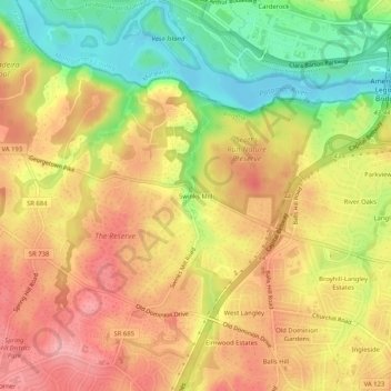
Name: Swinks Mill topographic map, elevation, terrain.
Location: Swinks Mill, Fairfax County, Virginia, 22102, United States (38.93817 -77.22470 38.97817 -77.18470)
Average elevation: 73 m
Minimum elevation: 12 m
Maximum elevation: 118 m
Make a donation
Other topographic maps
Click on a map to view its topography, its elevation and its terrain.
George Washington's Mount Vernon
United States > Virginia > Fairfax County > Mount Vernon
Average elevation: 14 m
Great Falls
United States > Virginia > Fairfax County > Great Falls
Great Falls is located at 38°59′53″N 077°17′18″W / 38.99806°N 77.28833°W / 38.99806; -77.28833 (38.9981653, −77.2883157) at an elevation of 344 feet (105 m). Located on Virginia State Route 7 in Northern Virginia, Great Falls is 15 miles (24 km) west-northwest of downtown Washington,…
Average elevation: 88 m
Wolf Trap National Park for the Performing Arts
United States > Virginia > Fairfax County > Wolf Trap > Shouse Village
Average elevation: 104 m
Make a donation
Belle Haven Park
United States > Virginia > Fairfax County > Alexandria > Westgrove
Average elevation: 8 m
Make a donation
Lake Fairfax Park
United States > Virginia > Fairfax County > Reston > Crowells Corner
Average elevation: 99 m
Make a donation
Cabell's Mill at Ellanor C. Lawerence Park
United States > Virginia > Fairfax County
Average elevation: 97 m
Make a donation