
Thank you for supporting this site ❤️
Make a donation
Make a donation
Croydon topographic map
Click on the map to display elevation.
Thank you for supporting this site ❤️
Make a donation
Make a donation
About this map
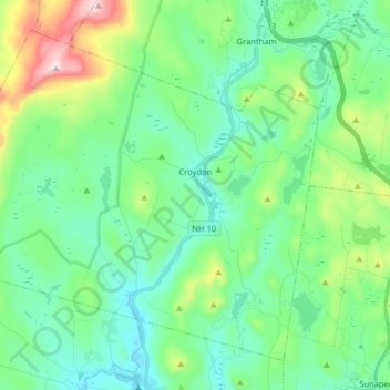
Name: Croydon topographic map, elevation, terrain.
Location: Croydon, Sullivan County, New Hampshire, United States (43.39440 -72.27186 43.49337 -72.11136)
Average elevation: 372 m
Minimum elevation: 228 m
Maximum elevation: 831 m
Thank you for supporting this site ❤️
Make a donation
Make a donation
Other topographic maps
Click on a map to view its topography, its elevation and its terrain.
Thank you for supporting this site ❤️
Make a donation
Make a donation
Mill Hollow
United States > New Hampshire > Sullivan County > Plainfield > Mill Hollow
Average elevation: 313 m