
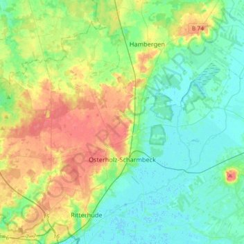
Osterholz-Scharmbeck topographic map
Interactive map
Click on the map to display elevation.
About this map
Name: Osterholz-Scharmbeck topographic map, elevation, terrain.
Average elevation: 18 m
Minimum elevation: -1 m
Maximum elevation: 52 m
Other topographic maps
Click on a map to view its topography, its elevation and its terrain.
Grasberg
Germany > Lower Saxony > Landkreis Osterholz
Grasberg, Landkreis Osterholz, Lower Saxony, 28879, Germany
Average elevation: 7 m
Hüttenbusch
Germany > Lower Saxony > Landkreis Osterholz > Worpswede
Hüttenbusch, Worpswede, Landkreis Osterholz, Lower Saxony, 27726, Germany
Average elevation: 5 m