
Hameau de Bel Air topographic map
Interactive map
Click on the map to display elevation.
About this map
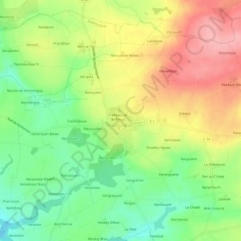
Name: Hameau de Bel Air topographic map, elevation, terrain.
Average elevation: 73 m
Minimum elevation: 16 m
Maximum elevation: 138 m
Other topographic maps
Click on a map to view its topography, its elevation and its terrain.
Brenterc'h
France > Bretagne > Finistère > Ploumoguer
Brenterc'h, Ploumoguer, Brest, Finistère, Bretagne, France métropolitaine, 29810, France
Average elevation: 21 m
Kerjean
France > Bretagne > Finistère > Ploumoguer
Kerjean, Ploumoguer, Brest, Finistère, Bretagne, France métropolitaine, 29810, France
Average elevation: 54 m
Le Bourg
France > Bretagne > Finistère > Ploumoguer
Le Bourg, Ploumoguer, Brest, Finistère, Bretagne, France métropolitaine, 29810, France
Average elevation: 71 m
Kerichen
France > Bretagne > Finistère > Ploumoguer
Kerichen, Ploumoguer, Brest, Finistère, Bretagne, France métropolitaine, 29810, France
Average elevation: 28 m
Kerouman
France > Bretagne > Finistère > Ploumoguer
Kerouman, Ploumoguer, Brest, Finistère, Bretagne, France métropolitaine, 29810, France
Average elevation: 74 m
Kerhornou
France > Bretagne > Finistère > Ploumoguer
Kerhornou, Ploumoguer, Brest, Finistère, Bretagne, France métropolitaine, 29810, France
Average elevation: 35 m