
Eimersdorf topographic map
Interactive map
Click on the map to display elevation.
About this map
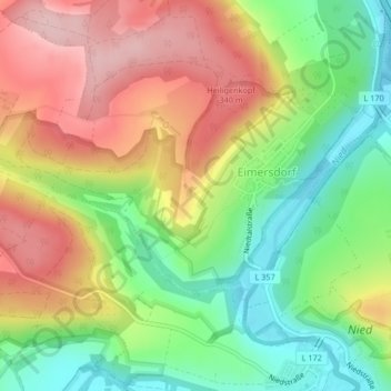
Name: Eimersdorf topographic map, elevation, terrain.
Average elevation: 265 m
Minimum elevation: 168 m
Maximum elevation: 371 m
Eimersdorf liegt räumlich zentral im Rehlingen-Siersburger Gemeindegebiet am linken Ufer der Nied in Halbhöhenlage an den Ausläufern des Niedgaues.
Other topographic maps
Click on a map to view its topography, its elevation and its terrain.
Fremersdorf
Deutschland > Saarland > Rehlingen-Siersburg
Fremersdorf, Rehlingen-Siersburg, Landkreis Saarlouis, Saarland, Deutschland
Average elevation: 275 m