
Thank you for supporting this site ❤️
Make a donation
Make a donation
Templeton topographic map
Click on the map to display elevation.
Thank you for supporting this site ❤️
Make a donation
Make a donation
About this map
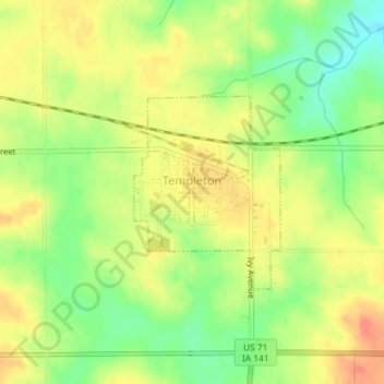
Name: Templeton topographic map, elevation, terrain.
Location: Templeton, Carroll County, Iowa, United States (41.91087 -94.94853 41.92445 -94.93466)
Average elevation: 434 m
Minimum elevation: 407 m
Maximum elevation: 455 m
Thank you for supporting this site ❤️
Make a donation
Make a donation
Other topographic maps
Click on a map to view its topography, its elevation and its terrain.