
Upper Chitral District topographic map
Interactive map
Click on the map to display elevation.
About this map
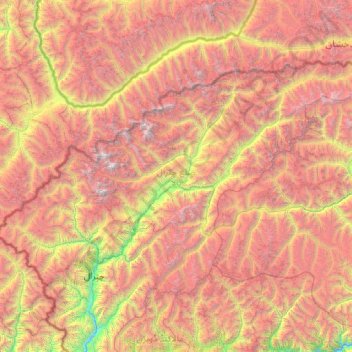
Name: Upper Chitral District topographic map, elevation, terrain.
Average elevation: 4,064 m
Minimum elevation: 1,341 m
Maximum elevation: 7,592 m
Other topographic maps
Click on a map to view its topography, its elevation and its terrain.
Nowshak
Pakistan > Khyber Pakhtunkhwa > ضلع چترال
Nowshak, Upper Chitral District, ضلع چترال, Division de Malakand, Khyber Pakhtunkhwa, Pakistan
Average elevation: 6,856 m
Saraghrar I
Pakistan > Khyber Pakhtunkhwa > ضلع چترال
Saraghrar I, Upper Chitral District, ضلع چترال, Division de Malakand, Khyber Pakhtunkhwa, Pakistan
Average elevation: 6,780 m