
Chichester topographic map
Interactive map
Click on the map to display elevation.
About this map
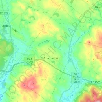
Name: Chichester topographic map, elevation, terrain.
Location: Chichester, Merrimack County, New Hampshire, United States (43.20092 -71.46267 43.31401 -71.33495)
Average elevation: 162 m
Minimum elevation: 81 m
Maximum elevation: 340 m
Other topographic maps
Click on a map to view its topography, its elevation and its terrain.
Kelleys Corner
United States > New Hampshire > Merrimack County > Chichester
Kelleys Corner, Chichester, Merrimack County, New Hampshire, 03258, United States
Average elevation: 158 m