
Make a donation
Palma topographic map
Click on the map to display elevation.
Make a donation
Palma
Palma is a major city and seaport located in the southwest of Mallorca, a western Mediterranean island belonging to the Balearic Islands archipelago. The land area of the city is about 21.355 square kilometres (8.245 sq mi) with an altitude of 13 metres (43 feet) above sea level.
Make a donation
About this map
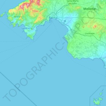
Name: Palma topographic map, elevation, terrain.
Location: Palma, Balearic Islands, Spain (39.12073 2.56385 39.65826 2.97986)
Average elevation: 45 m
Minimum elevation: -1 m
Maximum elevation: 955 m
Make a donation
Other topographic maps
Click on a map to view its topography, its elevation and its terrain.
Make a donation
Make a donation
sa Calobra
Spain > Balearic Islands > Serra de Tramuntana > Escorca
The port village is a popular destination for coach trips and road cyclists. It is accessed by a single winding road, designed by Italian-Spanish engineer Antonio Parietti and opened in 1933, which features many hairpin bends and a 270° spiral bridge called the tie knot. The climb is officially called the…
Average elevation: 256 m