
Lommato topographic map
Interactive map
Click on the map to display elevation.
About this map
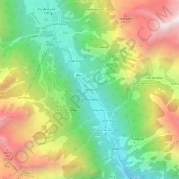
Name: Lommato topographic map, elevation, terrain.
Location: Lommato, Gressoney-Saint-Jean, Vallée d'Aoste, 11025, Italie (45.72925 7.82557 45.76925 7.86557)
Average elevation: 1,833 m
Minimum elevation: 1,177 m
Maximum elevation: 2,744 m
Other topographic maps
Click on a map to view its topography, its elevation and its terrain.
Schmetto
Italie > Vallée d'Aoste > Gressoney-Saint-Jean
Schmetto, Gressoney-Saint-Jean, Vallée d'Aoste, 11025, Italie
Average elevation: 2,042 m
Bino
Italie > Vallée d'Aoste > Gressoney-Saint-Jean > Bino
Bino, Gressoney-Saint-Jean, Vallée d'Aoste, 11025, Italie
Average elevation: 1,959 m
Ondre Tschossil
Italie > Vallée d'Aoste > Gressoney-Saint-Jean
Ondre Tschossil, Gressoney-Saint-Jean, Vallée d'Aoste, 11025, Italie
Average elevation: 1,811 m