
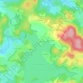
La Sapinière topographic map
Interactive map
Click on the map to display elevation.
About this map
Name: La Sapinière topographic map, elevation, terrain.
Average elevation: 603 m
Minimum elevation: 544 m
Maximum elevation: 710 m
Other topographic maps
Click on a map to view its topography, its elevation and its terrain.
Le Pré Gaumont
France > Bourgogne-Franche-Comté > Nièvre > Montsauche-les-Settons
Le Pré Gaumont, Montsauche-les-Settons, Château-Chinon (Ville), Nièvre, Bourgogne-Franche-Comté, France métropolitaine, 58230, France
Average elevation: 571 m
Champgazon
France > Bourgogne-Franche-Comté > Nièvre > Montsauche-les-Settons
Champgazon, Montsauche-les-Settons, Château-Chinon (Ville), Nièvre, Bourgogne-Franche-Comté, France métropolitaine, 58230, France
Average elevation: 586 m
Lac des Settons
France > Bourgogne-Franche-Comté > Nièvre > Montsauche-les-Settons
Lac des Settons, Montsauche-les-Settons, Château-Chinon (Ville), Nièvre, Bourgogne-Franche-Comté, France métropolitaine, 58230, France
Average elevation: 597 m
L'Huis Gaumont
France > Bourgogne-Franche-Comté > Nièvre > Montsauche-les-Settons > L'Huis Gaumont
L'Huis Gaumont, Montsauche-les-Settons, Château-Chinon (Ville), Nièvre, Bourgogne-Franche-Comté, France métropolitaine, 58230, France
Average elevation: 589 m
Les Settons
France > Bourgogne-Franche-Comté > Nièvre > Montsauche-les-Settons
Les Settons, Montsauche-les-Settons, Château-Chinon (Ville), Nièvre, Bourgogne-Franche-Comté, France métropolitaine, 58230, France
Average elevation: 591 m