
Samion topographic map
Interactive map
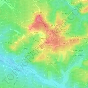
Click on the map to display elevation.
About this map
Name: Samion topographic map, elevation, terrain.
Average elevation: 53 m
Minimum elevation: 21 m
Maximum elevation: 100 m
Other topographic maps
Click on a map to view its topography, its elevation and its terrain.
Le Champ d'Ambrois
France > Nouvelle-Aquitaine > Gironde > Montagne
Le Champ d'Ambrois, Montagne, Libourne, Gironde, Nouvelle-Aquitaine, France métropolitaine, 33570, France
Average elevation: 53 m
La Clotte
France > Nouvelle-Aquitaine > Gironde > Montagne
La Clotte, Montagne, Libourne, Gironde, Nouvelle-Aquitaine, France métropolitaine, 33570, France
Average elevation: 54 m