
Thank you for supporting this site ❤️
Make a donation
Make a donation
Moinho Velho topographic map
Click on the map to display elevation.
Thank you for supporting this site ❤️
Make a donation
Make a donation
About this map
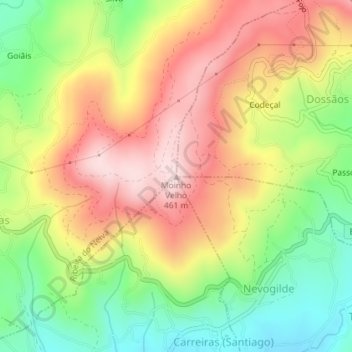
Name: Moinho Velho topographic map, elevation, terrain.
Average elevation: 290 m
Minimum elevation: 126 m
Maximum elevation: 453 m
Thank you for supporting this site ❤️
Make a donation
Make a donation
Other topographic maps
Click on a map to view its topography, its elevation and its terrain.
Lagoa da Cheira
Portugal > Norte > Vila Verde > Prado (São Miguel) > Prado (São Miguel)
Average elevation: 362 m