
Make a donation
Hudson topographic map
Click on the map to display elevation.
Make a donation
Hudson
The Assabet River runs prominently through most of Hudson. The river arises from wetlands in Westborough and flows northeast 34 miles (55 km), starting at an elevation of 320 feet (98 m). It descends through the towns of Northborough, Marlborough, Berlin, Hudson, Stow, Maynard, Acton, and finally Concord, where it merges with the Sudbury River to form the Concord River, at an elevation of 100 feet (30 m). The dam in central Hudson is one of nine historic mill or flood control dams on the Assabet River. A portion of the Assabet River National Wildlife Refuge is located in Hudson.
Make a donation
About this map
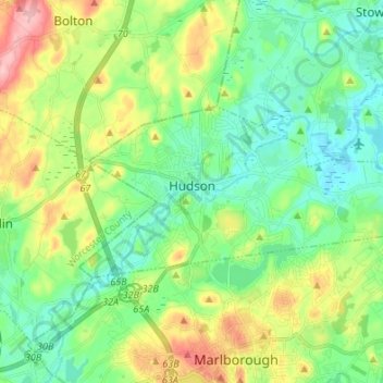
Name: Hudson topographic map, elevation, terrain.
Average elevation: 98 m
Minimum elevation: 51 m
Maximum elevation: 198 m
Make a donation
Other topographic maps
Click on a map to view its topography, its elevation and its terrain.
Make a donation
North Chelmsford
United States > Massachusetts > Middlesex County > Chelmsford
Average elevation: 41 m
Make a donation
Make a donation
Medford Hillside
United States > Massachusetts > Middlesex County > Medford > West Medford
Average elevation: 13 m
Make a donation
Hobbs Road
United States > Massachusetts > Middlesex County > Wayland > Cochituate
Average elevation: 66 m
Make a donation
Make a donation
Make a donation
Make a donation
North Chelmsford
United States > Massachusetts > Middlesex County > Chelmsford
Average elevation: 41 m
Make a donation
Arlington Heights
United States > Massachusetts > Middlesex County > Arlington
Average elevation: 58 m
Make a donation
Make a donation
Framingham Center
United States > Massachusetts > Middlesex County > Framingham
Average elevation: 58 m
Make a donation
Cambridge
United States > Massachusetts > Middlesex County > Cambridge
Cambridge obtains water from Hobbs Brook (in Lincoln and Waltham) and Stony Brook (Waltham and Weston), as well as an emergency connection to the Massachusetts Water Resources Authority. The city owns over 1,200 acres (486 ha) of land in other towns that includes these reservoirs and portions of their…
Average elevation: 31 m
Make a donation
Glendale
United States > Massachusetts > Middlesex County > Everett > Glendale
Average elevation: 14 m
Make a donation
East Acton
United States > Massachusetts > Middlesex County > Acton > East Acton
Average elevation: 53 m
Weston Station
United States > Massachusetts > Middlesex County > Weston > Weston Station
Average elevation: 55 m
Make a donation