Geolocate

Mentone topographic map

Interactive map

Click on the map to display elevation.

About this map

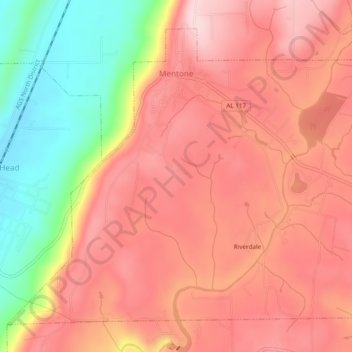
Name: Mentone topographic map, elevation, terrain.

Location: Mentone, DeKalb County, Alabama, 35984, United States (34.55130 -85.61363 34.58458 -85.56558)

Average elevation: 471 m

Minimum elevation: 307 m

Maximum elevation: 566 m

Mentone is located in eastern DeKalb County at 34°34′20″N 85°34′49″W / 34.57222°N 85.58028°W / 34.57222; -85.58028 (34.572360, -85.580283). It is bordered to the west by the town of Valley Head. The center of town is located on the crest of Lookout Mountain at an elevation of 1,736 feet (529 m). The western border of the town, with Valley Head, follows the western slopes of the mountain. Extending south from the town center is the mountain's ridgecrest that rises to an elevation of 1,785 feet (544 m) within the town limits. The West Fork of the Little River crosses the eastern portion of the town at an elevation less than 100 feet (30 m) below the ridgecrest.

Wikipedia (CC-BY-SA 3.0)

Other topographic maps

Click on a map to view its topography, its elevation and its terrain.

Fort Payne

United States > Alabama > DeKalb County

Fort Payne, DeKalb County, Alabama, 35967, United States

Average elevation: 369 m

Henagar

United States > Alabama > DeKalb County

Henagar, DeKalb County, Alabama, 35978, United States

Average elevation: 436 m

Grove Oak

United States > Alabama > DeKalb County

Grove Oak, DeKalb County, Alabama, 35975, United States

Average elevation: 344 m

Hammondville

United States > Alabama > DeKalb County

Hammondville, DeKalb County, Alabama, United States

Average elevation: 362 m

Shiloh

United States > Alabama > DeKalb County

Shiloh, DeKalb County, Alabama, United States

Average elevation: 376 m

Lakeview

United States > Alabama > DeKalb County

Lakeview, DeKalb County, Alabama, United States

Average elevation: 344 m

Valley Head

United States > Alabama > DeKalb County

Valley Head, DeKalb County, Alabama, United States

Average elevation: 410 m

Collinsville

United States > Alabama > DeKalb County

Collinsville, DeKalb County, Alabama, 35961, United States

Average elevation: 285 m

Rainsville

United States > Alabama > DeKalb County

Rainsville, DeKalb County, Alabama, 35986, United States

Average elevation: 380 m

Crossville

United States > Alabama > DeKalb County

Crossville, DeKalb County, Alabama, United States

Average elevation: 337 m

Powell

United States > Alabama > DeKalb County

Powell, DeKalb County, Alabama, United States

Average elevation: 380 m

Mentone

United States > Alabama > DeKalb County

Mentone, DeKalb County, Alabama, 35984, United States

Average elevation: 470 m

Geraldine

United States > Alabama > DeKalb County

Geraldine, DeKalb County, Alabama, 35974, United States

Average elevation: 349 m

Fyffe

United States > Alabama > DeKalb County

Fyffe, DeKalb County, Alabama, 35971, United States

Average elevation: 376 m

Pine Ridge

United States > Alabama > DeKalb County

Pine Ridge, DeKalb County, Alabama, United States

Average elevation: 312 m

Desoto State Park

United States > Alabama > DeKalb County > Fort Payne

Desoto State Park, Fort Payne, DeKalb County, Alabama, United States

Average elevation: 454 m

Minvale

United States > Alabama > DeKalb County > Fort Payne > Minvale

Minvale, Fort Payne, DeKalb County, Alabama, 35967, United States

Average elevation: 322 m

Little River Canyon National Preserve

United States > Alabama > DeKalb County > Fort Payne

Little River Canyon National Preserve, Fort Payne, DeKalb County, Alabama, United States

Average elevation: 328 m

Collinsville

United States > Alabama > DeKalb County > Collinsville

Collinsville, DeKalb County, Alabama, 35961, United States

Average elevation: 285 m

Ider

United States > Alabama > DeKalb County

Ider, DeKalb County, Alabama, United States

Average elevation: 467 m

Fort Payne

United States > Alabama > DeKalb County > Fort Payne

Fort Payne, DeKalb County, Alabama, 35967, United States

Average elevation: 350 m

Red Hill

United States > Alabama > DeKalb County

Red Hill, DeKalb County, Alabama, United States

Average elevation: 255 m

Sylvania

United States > Alabama > DeKalb County

Sylvania, DeKalb County, Alabama, 35988, United States

Average elevation: 405 m