
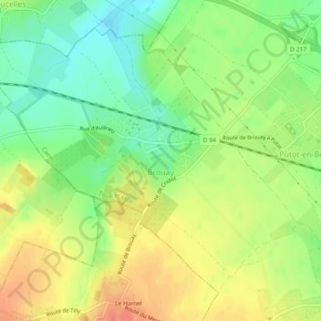
Brouay topographic map
Interactive map
Click on the map to display elevation.
About this map
Name: Brouay topographic map, elevation, terrain.
Average elevation: 71 m
Minimum elevation: 47 m
Maximum elevation: 95 m
Other topographic maps
Click on a map to view its topography, its elevation and its terrain.
La Guinguette
France > Normandie > Calvados > Thue et Mue > Cheux
La Guinguette, Cheux, Thue et Mue, Caen, Calvados, Normandie, France métropolitaine, 14210, France
Average elevation: 82 m
Putot-en-Bessin
France > Normandie > Calvados > Thue et Mue
Putot-en-Bessin, Thue et Mue, Caen, Calvados, Normandie, France métropolitaine, 14740, France
Average elevation: 67 m
Sainte-Croix-Grand-Tonne
France > Normandie > Calvados > Thue et Mue
Sainte-Croix-Grand-Tonne, Thue et Mue, Caen, Calvados, Normandie, France métropolitaine, 14740, France
Average elevation: 63 m