
Thank you for supporting this site ❤️
Make a donation
Make a donation
Ranten topographic map
Click on the map to display elevation.
Thank you for supporting this site ❤️
Make a donation
Make a donation
About this map
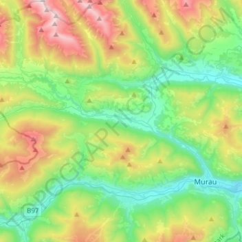
Name: Ranten topographic map, elevation, terrain.
Location: Ranten, Bezirk Murau, Styria, 8853, Austria (47.12838 13.94275 47.18094 14.19165)
Average elevation: 1,347 m
Minimum elevation: 777 m
Maximum elevation: 2,560 m
Thank you for supporting this site ❤️
Make a donation
Make a donation
Other topographic maps
Click on a map to view its topography, its elevation and its terrain.
Thank you for supporting this site ❤️
Make a donation
Make a donation
Thank you for supporting this site ❤️
Make a donation
Make a donation
Thank you for supporting this site ❤️
Make a donation
Make a donation
Sankt Ruprecht ob Murau
Austria > Styria > Bezirk Murau > Sankt Georgen am Kreischberg
Average elevation: 1,204 m