
Shantou topographic map
Interactive map
Click on the map to display elevation.
About this map
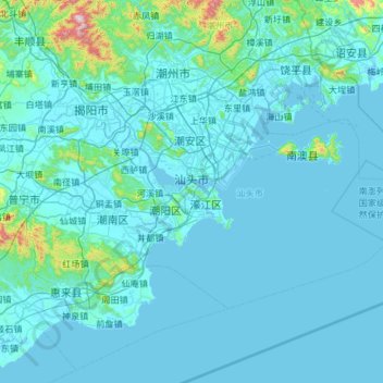
Name: Shantou topographic map, elevation, terrain.
Location: Shantou, Guangdong, China (23.03488 116.23961 23.64342 117.38674)
Average elevation: 58 m
Minimum elevation: -2 m
Maximum elevation: 1,230 m
Other topographic maps
Click on a map to view its topography, its elevation and its terrain.
Leizhou-Halbinsel
Leizhou-Halbinsel, 207国道, 东坡南村, 雷州市 (Leizhou), 湛江市 / Zhanjiang, Guangdong, China
Average elevation: 29 m