
Make a donation
Blaar topographic map
Click on the map to display elevation.
Make a donation
About this map
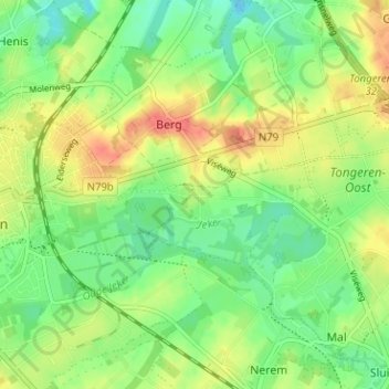
Name: Blaar topographic map, elevation, terrain.
Location: Blaar, Tongeren, Limburg, 3700, België (50.76358 5.47931 50.80358 5.51931)
Average elevation: 94 m
Minimum elevation: 71 m
Maximum elevation: 122 m
Make a donation
Other topographic maps
Click on a map to view its topography, its elevation and its terrain.
Lauw
België > Limburg > Tongeren > Tongeren
Lauw bevindt zich in droog-Haspengouw, aan de vallei van de Jeker. De hoogte varieert tussen 93 en 133 meter. Op het plateau wordt landbouw bedreven: tarwe, gerst en suikerbieten. Bij de Daalbron, die vanaf 1903 de stad Tongeren van water voorzag, wordt waterkers gekweekt.
Average elevation: 110 m
Piringen
België > Limburg > Tongeren > Tongeren
Piringen ligt in vochtig-Haspengouw, op een hoogte van 65 tot 107 meter. Ten noorden van Piringen begint een beekje dat uitmondt in de Fonteinbeek. De vallei hiervan, met de steilrand naar de Ganzenberg, is aangewezen als natuurgebied. Het is vochtig en heeft een bijzondere flora en fauna. Op het plateau, dat…
Average elevation: 84 m
Mal
België > Limburg > Tongeren > Tongeren > Mal
Mal is gelegen op de grens van vochtig- en droog-Haspengouw, op de linkeroever van de Jeker. De hoogte bedraagt 85 tot 112 meter. Ten westen van Mal ligt een uitgestrekt natuurgebied, het Landschapspark van de Oostelijke Jeker, bestaande uit moerassige biotopen. Verder van de Jeker af is de bodem vooral voor…
Average elevation: 97 m
Diets-Heur
België > Limburg > Tongeren > Tongeren
Diets-Heur bevindt zich in droog-Haspengouw op een hoogte van 97 tot 137 meter. De enige waterloop is het beekje de Buth, dat in noordoostelijke richting stroomt. Het dorp ligt aan de taalgrens.
Average elevation: 124 m
Make a donation
Neerrepen
België > Limburg > Tongeren > Tongeren
Neerrepen ligt in vochtig-Haspengouw op een hoogte van 67 tot 110 meter. De Lerebeek of Winterbeek loopt langs het dorp in noordwestelijke richting om bij Guigoven in de Mombeek uit te monden. Vanuit het beekdal leiden holle wegen naar het plateau. Daar wordt de landbouw (graan, grasland) en de fruitteelt…
Average elevation: 89 m
Riksingen
België > Limburg > Tongeren > Tongeren
Riksingen bevindt zich op de grens van vochtig- en droog-Haspengouw. De hoogte varieert tussen 80 en 120 meter. Ten westen van Riksingen ligt het brongebied van de Lerebeek, welke via de Mombeek en de Herk uiteindelijk in de Demer uitmondt. Het belangrijkste natuurgebied is het Hasselbos, dat zich ten noorden…
Average elevation: 93 m
Berg
België > Limburg > Tongeren > Tongeren
Berg ligt op de grens van droog- en vochtig-Haspengouw en op de waterscheiding tussen de Jeker en de Demer (Maas en Schelde). De hoogte varieert tussen 80 en 123 meter. Het hoogste punt is de Galgenberg, en ook de kerk van het dorp ligt op een aanzienlijke hoogte boven de omringende valleien.
Average elevation: 92 m
Make a donation