
Thank you for supporting this site ❤️
Make a donation
Make a donation
Kaduna State topographic map
Click on the map to display elevation.
Thank you for supporting this site ❤️
Make a donation
Make a donation
About this map
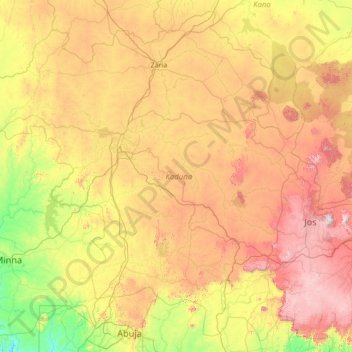
Name: Kaduna State topographic map, elevation, terrain.
Location: Kaduna State, Nigeria (9.00064 6.08653 11.52377 8.82352)
Average elevation: 634 m
Minimum elevation: 122 m
Maximum elevation: 1,671 m
Thank you for supporting this site ❤️
Make a donation
Make a donation
Other topographic maps
Click on a map to view its topography, its elevation and its terrain.