
Cheraga topographic map
Interactive map
Click on the map to display elevation.
About this map
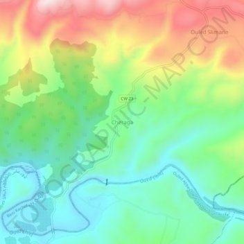
Name: Cheraga topographic map, elevation, terrain.
Location: Cheraga, Beni Rachid, Daïra Oued Fodda, Chlef, Algérie (36.23341 1.50482 36.27341 1.54482)
Average elevation: 288 m
Minimum elevation: 124 m
Maximum elevation: 579 m
Other topographic maps
Click on a map to view its topography, its elevation and its terrain.
El Ancer
Algérie > Chlef > Daïra Oued Fodda > Beni Rachid
El Ancer, Beni Rachid, Daïra Oued Fodda, Chlef, Algérie
Average elevation: 459 m