
Kerinci Seblat National Park topographic map
Interactive map
Click on the map to display elevation.
About this map
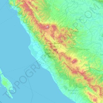
Name: Kerinci Seblat National Park topographic map, elevation, terrain.
Location: Kerinci Seblat National Park, Sungai Penuh, Jambi, Indonesia (-3.45101 100.58078 -1.07372 102.85709)
Average elevation: 339 m
Minimum elevation: -1 m
Maximum elevation: 3,751 m
Other topographic maps
Click on a map to view its topography, its elevation and its terrain.
Bukit Batu Asah
Indonesia > Jambi > Sungai Penuh
Bukit Batu Asah, Sungai Penuh, Air Hangat Timur, Jambi, Indonesia
Average elevation: 1,253 m