
Thank you for supporting this site ❤️
Make a donation
Make a donation
Grand Sart topographic map
Click on the map to display elevation.
Thank you for supporting this site ❤️
Make a donation
Make a donation
About this map
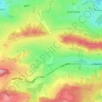
Name: Grand Sart topographic map, elevation, terrain.
Location: Grand Sart, Lierneux, Verviers, Luik, Wallonië, 4990, België (50.25349 5.83215 50.29349 5.87215)
Average elevation: 465 m
Minimum elevation: 383 m
Maximum elevation: 563 m
Thank you for supporting this site ❤️
Make a donation
Make a donation