
Thank you for supporting this site ❤️
Make a donation
Make a donation
Jadhana topographic map
Click on the map to display elevation.
Thank you for supporting this site ❤️
Make a donation
Make a donation
About this map
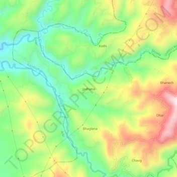
Name: Jadhana topographic map, elevation, terrain.
Location: Jadhana, Kandaghat, Solan, Himachal Pradesh, 173208, India (31.08094 76.98223 31.12094 77.02223)
Average elevation: 1,043 m
Minimum elevation: 856 m
Maximum elevation: 1,308 m
Thank you for supporting this site ❤️
Make a donation
Make a donation
Other topographic maps
Click on a map to view its topography, its elevation and its terrain.