
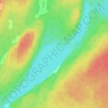
Lac Geneviève topographic map
Interactive map
Click on the map to display elevation.
About this map
Name: Lac Geneviève topographic map, elevation, terrain.
Average elevation: 91 m
Minimum elevation: 63 m
Maximum elevation: 119 m
Other topographic maps
Click on a map to view its topography, its elevation and its terrain.
Lac Larouche
Canada > Québec > Minganie > L'Île-d'Anticosti
Lac Larouche, L'Île-d'Anticosti, Minganie, Côte-Nord, Québec, Canada
Average elevation: 47 m
Lac Gamache
Canada > Québec > Minganie > L'Île-d'Anticosti
Lac Gamache, L'Île-d'Anticosti, Minganie, Côte-Nord, Québec, Canada
Average elevation: 41 m
Lac Clair
Canada > Québec > Minganie > L'Île-d'Anticosti
Lac Clair, L'Île-d'Anticosti, Minganie, Côte-Nord, Québec, Canada
Average elevation: 199 m
Île Anticosti
Canada > Québec > Minganie > L'Île-d'Anticosti
Île Anticosti, L'Île-d'Anticosti, Minganie, Côte-Nord, Québec, Canada
Average elevation: 37 m
Port-Menier
Canada > Québec > Minganie > L'Île-d'Anticosti
Port-Menier, L'Île-d'Anticosti, Minganie, Côte-Nord, Québec, Canada
Average elevation: 8 m