
Hohwarth topographic map
Interactive map
Click on the map to display elevation.
About this map
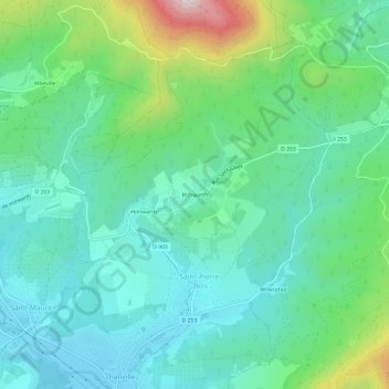
Name: Hohwarth topographic map, elevation, terrain.
Average elevation: 376 m
Minimum elevation: 230 m
Maximum elevation: 821 m
Other topographic maps
Click on a map to view its topography, its elevation and its terrain.
Hohwarth
France > Grand Est > Bas-Rhin > Saint-Pierre-Bois
Hohwarth, Saint-Pierre-Bois, Sélestat-Erstein, Bas-Rhin, Grand Est, France métropolitaine, 67220, France
Average elevation: 352 m