
Thank you for supporting this site ❤️
Make a donation
Make a donation
Balve topographic map
Click on the map to display elevation.
Thank you for supporting this site ❤️
Make a donation
Make a donation
About this map
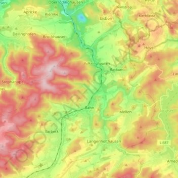
Name: Balve topographic map, elevation, terrain.
Location: Balve, Märkischer Kreis, North Rhine-Westphalia, 58802, Germany (51.28961 7.77297 51.39792 7.93401)
Average elevation: 329 m
Minimum elevation: 122 m
Maximum elevation: 547 m
Thank you for supporting this site ❤️
Make a donation
Make a donation
Other topographic maps
Click on a map to view its topography, its elevation and its terrain.
Rotthausen
Germany > North Rhine-Westphalia > Märkischer Kreis > Schalksmühle
Average elevation: 343 m
Gelstern
Germany > North Rhine-Westphalia > Märkischer Kreis > Schalksmühle > Heedfeld
Average elevation: 385 m
Moßberg
Germany > North Rhine-Westphalia > Märkischer Kreis > Menden (Sauerland)
Average elevation: 220 m
Thank you for supporting this site ❤️
Make a donation
Make a donation
Blechen
Germany > North Rhine-Westphalia > Märkischer Kreis > Kierspe > Blechen
Average elevation: 376 m