
Make a donation
Votorantim topographic map
Click on the map to display elevation.
Make a donation
Votorantim
Em 1914, foi construída a usina hidrelétrica de Itupararanga, aproveitando a topografia do município e seu potencial hidrelétrico. Outras usinas no rio Grande vieram na sequência, como Light, Santa Helena, Votocel e Cachoeira da Chave.
Make a donation
About this map
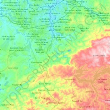
Name: Votorantim topographic map, elevation, terrain.
Average elevation: 717 m
Minimum elevation: 546 m
Maximum elevation: 1,026 m
Make a donation
Other topographic maps
Click on a map to view its topography, its elevation and its terrain.
Comunidade Ribeirão da Anta
Brasil > São Paulo > Região Metropolitana de Sorocaba > Tapiraí
Average elevation: 389 m
Córrego Itaim Mirim
Brasil > São Paulo > Região Metropolitana de Sorocaba > Itu
Average elevation: 552 m
Jardim São Paulo
Brasil > São Paulo > Região Metropolitana de Sorocaba > Sorocaba
Average elevation: 628 m
Fazenda Boa Vista
Brasil > São Paulo > Região Metropolitana de Sorocaba > Sarapuí
Average elevation: 571 m
Make a donation
Parque Ecológico Municipal Zila Sisternas Fiorenzo – da Biquinha
Brasil > São Paulo > Região Metropolitana de Sorocaba > Sorocaba
Average elevation: 581 m
Praça da Bíblia
Brasil > São Paulo > Região Metropolitana de Sorocaba > Cesário Lange
Average elevation: 622 m
Jardim Itália
Brasil > São Paulo > Região Metropolitana de Sorocaba > Sorocaba
Average elevation: 575 m
Jardim Fátima
Brasil > São Paulo > Região Metropolitana de Sorocaba > Sorocaba
Average elevation: 570 m
Make a donation
Praça Professora Amélia Cesar Machado de Araújo
Brasil > São Paulo > Região Metropolitana de Sorocaba > Sorocaba
Average elevation: 614 m
Praça Martinho Guedes
Brasil > São Paulo > Região Metropolitana de Sorocaba > Tatuí
Average elevation: 594 m
Morro do Saboó
Brasil > São Paulo > Região Metropolitana de Sorocaba > São Roque
Average elevation: 775 m
Parque Florestal Municipal Pedro Paes de Almeida
Brasil > São Paulo > Região Metropolitana de Sorocaba > Sorocaba
Average elevation: 583 m
Make a donation
Brigadeiro Tobias
Brasil > São Paulo > Região Metropolitana de Sorocaba > Sorocaba
Average elevation: 670 m
Cajuru do Sul
Brasil > São Paulo > Região Metropolitana de Sorocaba > Sorocaba
Average elevation: 596 m
Make a donation
Vila Jardini
Brasil > São Paulo > Região Metropolitana de Sorocaba > Sorocaba
Average elevation: 605 m
Praça Frei Baraúna
Brasil > São Paulo > Região Metropolitana de Sorocaba > Sorocaba
Average elevation: 577 m
Dona Catarina
Brasil > São Paulo > Região Metropolitana de Sorocaba > Mairinque
Average elevation: 793 m
Parque Campolim
Brasil > São Paulo > Região Metropolitana de Sorocaba > Sorocaba
Average elevation: 619 m
Make a donation
Jardim Mariana
Brasil > São Paulo > Região Metropolitana de Sorocaba > Sorocaba
Average elevation: 600 m
Bacia de Contenção de Enchentes Jardim Abaeté
Brasil > São Paulo > Região Metropolitana de Sorocaba > Sorocaba
Average elevation: 574 m
Jardim Botânico
Brasil > São Paulo > Região Metropolitana de Sorocaba > Sorocaba
Average elevation: 583 m
Make a donation
Estância da Colina
Brasil > São Paulo > Região Metropolitana de Sorocaba > Salto
Average elevation: 521 m
Parquinho dos Coelhos
Brasil > São Paulo > Região Metropolitana de Sorocaba > São Roque
Average elevation: 892 m
Make a donation
Sorocaba
Brasil > São Paulo > Região Metropolitana de Sorocaba > Sorocaba
O relevo é classificado como ondulado, caracterizado por vertentes e altos de serra, com altitude média de 632 metros em relação ao nível do mar. A maior altitude é de 1.028 metros, nas cabeceiras do rio Pirajibu, na Serra de São Francisco, próximo a Alumínio. A menor altitude 539 metros está no vale…
Average elevation: 662 m
Vila Rio Branco
Brasil > São Paulo > Região Metropolitana de Sorocaba > Itapetininga
Average elevation: 654 m
Rio Sarapuí
Brasil > São Paulo > Região Metropolitana de Sorocaba > Salto de Pirapora
Average elevation: 567 m
Make a donation
Praça Coronel Manoel Joaquim de Oliveira Carvalho
Brasil > São Paulo > Região Metropolitana de Sorocaba > Ibiúna
Average elevation: 866 m
Parque da Biodiversidade Marco Flávio da Costa Chaves
Brasil > São Paulo > Região Metropolitana de Sorocaba > Sorocaba
Average elevation: 585 m
Coqueiro
Brasil > São Paulo > Região Metropolitana de Sorocaba > Araçariguama > Bairro Laranja Azeda
Average elevation: 690 m
Make a donation
Morro da Pedreira
Brasil > São Paulo > Região Metropolitana de Sorocaba > Iperó
Average elevation: 590 m
Make a donation
Chácara Refúgio
Brasil > São Paulo > Região Metropolitana de Sorocaba > Sorocaba
Average elevation: 610 m
Jardim Paulistano
Brasil > São Paulo > Região Metropolitana de Sorocaba > Sorocaba
Average elevation: 589 m
Jardim Santa Cristina
Brasil > São Paulo > Região Metropolitana de Sorocaba > Sorocaba
Average elevation: 563 m
Jardim São Marcos
Brasil > São Paulo > Região Metropolitana de Sorocaba > Sorocaba
Average elevation: 621 m
Make a donation
Vila Dominguinhos
Brasil > São Paulo > Região Metropolitana de Sorocaba > Votorantim
Average elevation: 601 m
Praça Vereador João Batista Carmelo
Brasil > São Paulo > Região Metropolitana de Sorocaba > Ibiúna
Average elevation: 869 m
Rua Isolina Lopes
Brasil > São Paulo > Região Metropolitana de Sorocaba > Boituva
Average elevation: 595 m
Vila Nova Esperança
Brasil > São Paulo > Região Metropolitana de Sorocaba > Sorocaba
Average elevation: 609 m
Make a donation
Bairro do Saltinho
Brasil > São Paulo > Região Metropolitana de Sorocaba > Ibiúna
Average elevation: 997 m
Jardim Santa Isabel
Brasil > São Paulo > Região Metropolitana de Sorocaba > Salto de Pirapora
Average elevation: 617 m
Residencial Altos do Varvito
Brasil > São Paulo > Região Metropolitana de Sorocaba > Itu
Average elevation: 569 m
Fazenda Vila Real de Itu
Brasil > São Paulo > Região Metropolitana de Sorocaba > Itu
Average elevation: 574 m
Make a donation
Jardim Novo Horizonte
Brasil > São Paulo > Região Metropolitana de Sorocaba > Sorocaba
Average elevation: 599 m
Parque do Varvito
Brasil > São Paulo > Região Metropolitana de Sorocaba > Itu
Average elevation: 566 m
Jardim América
Brasil > São Paulo > Região Metropolitana de Sorocaba > Sorocaba
Average elevation: 601 m
Jardim Vergínia
Brasil > São Paulo > Região Metropolitana de Sorocaba > Sorocaba
Average elevation: 600 m
Make a donation
Jardim dos Estados
Brasil > São Paulo > Região Metropolitana de Sorocaba > Sorocaba
Average elevation: 608 m
Jardim Faculdade
Brasil > São Paulo > Região Metropolitana de Sorocaba > Sorocaba
Average elevation: 585 m
Terras de São José
Brasil > São Paulo > Região Metropolitana de Sorocaba > Itu
Average elevation: 606 m
Jardim das Orquídeas
Brasil > São Paulo > Região Metropolitana de Sorocaba > Sorocaba
Average elevation: 574 m
Make a donation
Bairro dos Alves
Brasil > São Paulo > Região Metropolitana de Sorocaba > Ibiúna
Average elevation: 962 m
Jardim Marcelo Augusto
Brasil > São Paulo > Região Metropolitana de Sorocaba > Sorocaba
Average elevation: 592 m
Jardim das Tulipas
Brasil > São Paulo > Região Metropolitana de Sorocaba > Sorocaba
Average elevation: 626 m
Bairro dos Grilos
Brasil > São Paulo > Região Metropolitana de Sorocaba > Ibiúna
Average elevation: 897 m
Make a donation
Mato-Dentro
Brasil > São Paulo > Região Metropolitana de Sorocaba > Cerquilho
Average elevation: 544 m
Condomínio Monte Belo
Brasil > São Paulo > Região Metropolitana de Sorocaba > Salto
Average elevation: 606 m
Make a donation
Mato Dentro
Brasil > São Paulo > Região Metropolitana de Sorocaba > Mairinque
Average elevation: 672 m
Make a donation
Praça Frei Barauna
Brasil > São Paulo > Região Metropolitana de Sorocaba > Sorocaba
Average elevation: 578 m
Jardim Alvorada
Brasil > São Paulo > Região Metropolitana de Sorocaba > Sorocaba
Average elevation: 600 m
Make a donation
Bairro Vargem do Salto
Brasil > São Paulo > Região Metropolitana de Sorocaba > Ibiúna
Average elevation: 942 m
Vila Primavera
Brasil > São Paulo > Região Metropolitana de Sorocaba > Sorocaba
Average elevation: 600 m
Jardim Maria Eugênia
Brasil > São Paulo > Região Metropolitana de Sorocaba > Sorocaba
Average elevation: 595 m
Jardim Santa Cecília
Brasil > São Paulo > Região Metropolitana de Sorocaba > Sorocaba
Average elevation: 586 m
Make a donation
Parque das Águas do Abaeté Maria Barbosa Silva
Brasil > São Paulo > Região Metropolitana de Sorocaba > Sorocaba
Average elevation: 569 m
Jardim Tatiana (Sorocaba)
Brasil > São Paulo > Região Metropolitana de Sorocaba > Sorocaba
Average elevation: 628 m
Make a donation
Barreiro Rico
Brasil > São Paulo > Região Metropolitana de Sorocaba > Cerquilho > Barreiro Rico
Average elevation: 544 m
Mirante da Floresta
Brasil > São Paulo > Região Metropolitana de Sorocaba > Salto
Average elevation: 535 m
Quatro e Meio
Brasil > São Paulo > Região Metropolitana de Sorocaba > Quatro e Meio
Average elevation: 637 m
Make a donation
Praça de Eventos Lecy de Campos
Brasil > São Paulo > Região Metropolitana de Sorocaba > Votorantim
Average elevation: 597 m
São João de Ipanema
Brasil > São Paulo > Região Metropolitana de Sorocaba > Iperó > São João de Ipanema
Average elevation: 609 m
Make a donation
Praça Martim Affonso
Brasil > São Paulo > Região Metropolitana de Sorocaba > Sorocaba
Average elevation: 574 m
Rio das Corujas
Brasil > São Paulo > Região Metropolitana de Sorocaba > Juquiá
Average elevation: 110 m
Jardim Camila
Brasil > São Paulo > Região Metropolitana de Sorocaba > Sorocaba
Average elevation: 604 m
Jardim Simus III
Brasil > São Paulo > Região Metropolitana de Sorocaba > Sorocaba
Average elevation: 610 m
Make a donation
Bairro da Ressaca
Brasil > São Paulo > Região Metropolitana de Sorocaba > Ibiúna
Average elevation: 885 m
Bairro dos Buenos
Brasil > São Paulo > Região Metropolitana de Sorocaba > Piedade
Average elevation: 815 m
Praça Rotary Club de Sorocaba Art Nossa
Brasil > São Paulo > Região Metropolitana de Sorocaba > Sorocaba
Average elevation: 581 m
Parque Natural Juracy Antônio Boaro
Brasil > São Paulo > Região Metropolitana de Sorocaba > Sorocaba
Average elevation: 595 m
Make a donation