
Saint Leonards Park topographic map
Interactive map
Click on the map to display elevation.
About this map
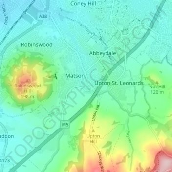
Name: Saint Leonards Park topographic map, elevation, terrain.
Average elevation: 72 m
Minimum elevation: 20 m
Maximum elevation: 249 m
Other topographic maps
Click on a map to view its topography, its elevation and its terrain.
North Matson
United Kingdom > England > Gloucestershire > Gloucester
North Matson, Gloucester, Gloucestershire, England, United Kingdom
Average elevation: 52 m
White City
United Kingdom > England > Gloucestershire > Gloucester
White City, Gloucester, Gloucestershire, England, GL4 6UL, United Kingdom
Average elevation: 38 m
Kings Barton
United Kingdom > England > Gloucestershire > Gloucester
Kings Barton, Gloucester, Gloucestershire, England, GL1 1QT, United Kingdom
Average elevation: 20 m
Lower Rea
United Kingdom > England > Gloucestershire > Gloucester
Lower Rea, Quedgeley, Gloucester, Gloucestershire, England, GL2 3NW, United Kingdom
Average elevation: 17 m
Quedgeley
United Kingdom > England > Gloucestershire > Gloucester
Quedgeley, Gloucester, Gloucestershire, England, United Kingdom
Average elevation: 20 m
Abbeymead Contour Park
United Kingdom > England > Gloucestershire > Gloucester
Abbeymead Contour Park, Abbeydale, Gloucester, Gloucestershire, England, United Kingdom
Average elevation: 46 m