
Thank you for supporting this site ❤️
Make a donation
Make a donation
Ventanilla topographic map
Click on the map to display elevation.
Thank you for supporting this site ❤️
Make a donation
Make a donation
About this map
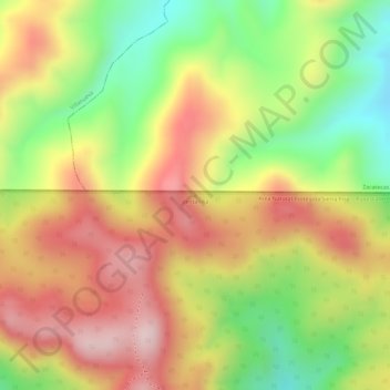
Name: Ventanilla topographic map, elevation, terrain.
Location: Ventanilla, San José de Gracia, Aguascalientes, Mexico (22.29113 -102.60388 22.29123 -102.60378)
Average elevation: 2,837 m
Minimum elevation: 2,657 m
Maximum elevation: 2,985 m
Thank you for supporting this site ❤️
Make a donation
Make a donation
Other topographic maps
Click on a map to view its topography, its elevation and its terrain.