
Thank you for supporting this site ❤️
Make a donation
Make a donation
Lingelbach topographic map
Click on the map to display elevation.
Thank you for supporting this site ❤️
Make a donation
Make a donation
About this map
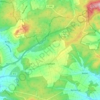
Name: Lingelbach topographic map, elevation, terrain.
Location: Lingelbach, Alsfeld, Vogelsbergkreis, Hessen, Deutschland (50.74288 9.35987 50.79544 9.46126)
Average elevation: 377 m
Minimum elevation: 288 m
Maximum elevation: 540 m
Thank you for supporting this site ❤️
Make a donation
Make a donation
Other topographic maps
Click on a map to view its topography, its elevation and its terrain.