
Thank you for supporting this site ❤️
Make a donation
Make a donation
Triós topographic map
Click on the map to display elevation.
Thank you for supporting this site ❤️
Make a donation
Make a donation
About this map
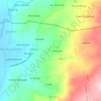
Name: Triós topographic map, elevation, terrain.
Location: Triós, O Pereiro de Aguiar, Orense, Galicia, España (42.34943 -7.74795 42.36515 -7.72379)
Average elevation: 487 m
Minimum elevation: 378 m
Maximum elevation: 666 m
Thank you for supporting this site ❤️
Make a donation
Make a donation
Other topographic maps
Click on a map to view its topography, its elevation and its terrain.
Thank you for supporting this site ❤️
Make a donation
Make a donation
Thank you for supporting this site ❤️
Make a donation
Make a donation