Curaçao topographic map
Interactive map
Click on the map to display elevation.
About this map
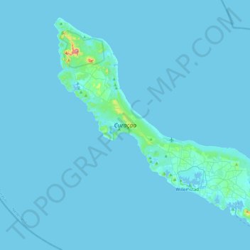
Name: Curaçao topographic map, elevation, terrain.
Location: Curaçao, Curacao, Netherlands (12.03427 -69.16271 12.39273 -68.73664)
Average elevation: 7 m
Minimum elevation: -1 m
Maximum elevation: 322 m
Curaçao, as well as the rest of the ABC islands and Trinidad and Tobago, lies on the continental shelf of South America. It is a thin island with a generally hilly topography; the highest point is Christoffelberg in the northwest, with a peak at 372 m (1,220 ft) above sea level. The coastline's bays, inlets and hot springs offer a source of natural minerals, thermal conditions, and seawater used in hydrotherapy and mesotherapy, making the island one of many balneoclimateric areas in the region. Off the southeast coast lies the small, flat island of Klein Curaçao.
Other topographic maps
Click on a map to view its topography, its elevation and its terrain.
Bergen aan Zee
Bergen aan Zee, Bergen, North Holland, Netherlands
Average elevation: 6 m
Nijverdal
Nijverdal, Hellendoorn, Overijssel, Netherlands
Average elevation: 18 m
Bergen op Zoom
Bergen op Zoom, North Brabant, Netherlands
Average elevation: 5 m
Hoeksche Waard
Hoeksche Waard, South Holland, Netherlands
Average elevation: 0 m
Kaag
Kaag, Kaag en Braassem, South Holland, Netherlands
Average elevation: -2 m
Voorne-Putten
Voorne-Putten, South Holland, Netherlands
Average elevation: 1 m
Eindhoven
Netherlands > North Brabant > Eindhoven
Eindhoven, North Brabant, Netherlands, 5611EB, Netherlands
Average elevation: 21 m
Rotterdam
Netherlands > South Holland > Rotterdam
Rotterdam, South Holland, Netherlands
Average elevation: 0 m
Dieren
Netherlands > Gelderland > Dieren
Dieren, Rheden, Gelderland, Netherlands
Average elevation: 20 m
Hilversum
Netherlands > North Holland > Hilversum
Hilversum, North Holland, Netherlands
Average elevation: 5 m
Culemborg
Netherlands > Utrecht > Culemborg
Culemborg, Vijfheerenlanden, Utrecht, Netherlands
Average elevation: 2 m
Maastricht
Netherlands > Limburg > Maastricht
Maastricht, Eijsden-Margraten, Limburg, Netherlands
Average elevation: 73 m
Haarlem
Netherlands > North Holland > Haarlem
Haarlem, North Holland, Netherlands
Average elevation: 3 m
Noordwijk
Netherlands > South Holland > Noordwijk
Noordwijk, South Holland, Netherlands
Average elevation: 1 m
Eindhoven
Netherlands > North Brabant > Eindhoven
Eindhoven, North Brabant, Netherlands
Average elevation: 20 m
Schiphol
Netherlands > North Holland > Haarlemmermeer
Schiphol, Haarlemmermeer, North Holland, Netherlands
Average elevation: -2 m
Hoogerheide
Netherlands > North Brabant > Woensdrecht
Hoogerheide, Woensdrecht, North Brabant, Netherlands
Average elevation: 14 m
Mill
Netherlands > North Brabant > Mill en Sint Hubert
Mill, Mill en Sint Hubert, North Brabant, Netherlands
Average elevation: 14 m