
Thank you for supporting this site ❤️
Make a donation
Make a donation
Ganderkesee topographic map
Click on the map to display elevation.
Thank you for supporting this site ❤️
Make a donation
Make a donation
About this map
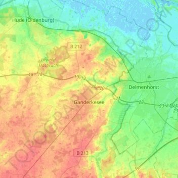
Name: Ganderkesee topographic map, elevation, terrain.
Location: Ganderkesee, Landkreis Oldenburg, Lower Saxony, 27777, Germany (52.96487 8.42516 53.12776 8.63551)
Average elevation: 20 m
Minimum elevation: -2 m
Maximum elevation: 47 m
Thank you for supporting this site ❤️
Make a donation
Make a donation
Other topographic maps
Click on a map to view its topography, its elevation and its terrain.